Global Climate Intelligence
Mitigate and manage risks from severe weather & climate change with Athenium’s patented, gap-free and model-ready databases — the world’s largest — both on a global scale and for singular locations.


Access more than 70 years of gap-free atmospheric and environmental historical insights.
Comprehensive
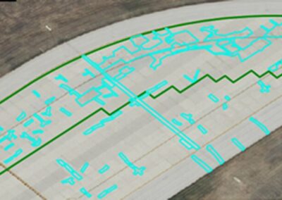
Athenium aggregates, normalizes and quality-controls information on 200+ climate & soil variables. They include variables that are key in operational and strategic planning, from precipitation and soil temperature to high-altitude wind speeds and solar irradiance. Granularities range from 9 miles to just above a half-mile.
Accessible
Athenium’s web-enabled, gap-free, normalized climate data, entirely hosted and supported in the cloud and available via API, empowers users to innovate at scale.
Global
Data intelligence from Athenium delivers historical patterns and insights for over 2.6 million grid cells around the globe. Our weather-data warehouse encompasses all 196 countries of the world, both polar regions and all oceans — providing reliable coverage no matter your mission location.

We originally developed our climatological data solutions in collaboration with investor In-Q-Tel, the private, non-profit venture fund which serves the CIA and broader U.S. Intelligence Community.
After initial releases with In-Q-Tel, Athenium deployed its capabilities in other applications for both public and commercial sectors.

Our solutions and APIs provide actionable climate insights with locations, variables and delivery tailored to your mission needs.
Athenium’s data engine ingests five billion observational and gridded data points daily. Extraction, transformation and data-loading tools, all developed by Athenium scientists and technologists, enrich and expand this historical collection.
The data sets — plus patented, dynamic weather-risk scoring — come model-ready and easy to use. End-users can select targeted locations, variables & time periods, gathering only the data needed to focus on mission objectives.
Historical Trend Analysis
- Analyze long-term weather and climate trends anywhere in the globe
- Integrate climatological intelligence with other datasets relevant to your mission
- Evaluate conditions and scenarios against your operational requirements


Post Event Forensics
- Access high-resolution storm data across 8 variables, including hail, tornadoes, wind & precipitation
- Quantify and assess the impact of severe weather at a single-location level
- Evaluate how storms may have impacted assets and operations with high-resolution, highly accurate data
News & Publications