Infrastructure Intelligence
Identify risks to public safety and national security arising from the condition, damageability and climate exposure of buildings, highways and runways by using automated solutions from Athenium.


Deploy Athenium’s patented AI to identify, expedite and reduce costs of analyzing infrastructure condition and damageability to inform decision-making in civilian and military operations.
Asset Identification and Assessment
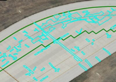
Leverage Athenium’s computer-vision technology that ingests high-resolution imagery from fixed-wing aircraft, satellites & drones, integrated with patented, dynamic weather-risk scoring.
Hazard Assessments
Utilize high-resolution risk scoring to quantify potential impacts to operations, infrastructure, materiel, readiness and performance exposed to severe natural hazards.
Predictive Damageability Modeling
Quantify the risk of future infrastructure degradation, damage and associated repair costs using Athenium’s predictive natural hazard damage models. This intelligence enables you to perform targeted and cost-effective operational maintenance and informs combat readiness.
Athenium partners with the United States Air Force to deliver infrastructure condition and damage risk assessments across both on-base assets and asset transportation networks. By providing the Air Force automated, AI-driven results at scale, personnel ranging from civil engineers to program managers to mission leaders can depend on Athenium infrastructure analytics to more effectively and safely plan operations.

Stay ahead of property and infrastructure risks.
Automate analysis of an asset’s current condition and receive actionable insights at scale. Athenium enables efficient scheduling of repairs while reducing expenses and increasing effectiveness for military and civilian engineering teams.
Patented analyses rate vulnerability using the probability & severity of natural hazards occurring for any location across the contiguous United States. Athenium offers tools to expand dynamic scoring into areas outside the U.S. that are most important to mission success.
Operational Maintenance
- Recurring condition reports at scale from Athenium help optimize repair identification & planning on a cost-effective basis
- Change-detection reports streamline identification of roadway asset deterioration over time
- Granular natural-hazard risk scoring & predictive damage insights detect risk distribution and severity across a network of roadways
- End-users easily integrate condition, hazard & damageability insights into their existing asset-management databases


Mission Readiness
- Upload imagery of locations from across the globe to automatically identify paved surface candidates that appear adequate for aircraft landings
- Tailor AI search criteria to identify possible landing strips for multiple aircraft types, sizes and purposes
- Utilize reports containing surface length, width, slope & other criteria for each qualified surface for both short- and long-term mission planning
News & Publications