The Climate Dashboard
Innovative Solutions Across the Insurance Workflow
Actionable and comprehensive climate data – from underwriting and forecasting to post event claim analysis.


Athenium helps insurers make faster, more informed decisions.
Athenium enables insurance carriers to find new opportunities for growth, efficiency and continuous improvement. We offer industry-leading insurtech software that helps carriers drive quality, improve performance and write smarter business using predictive analytics and actionable insights.
smart Underwriting
Identify potential risks and natural hazards before you write.
hurricane forecasting
Track the path of oncoming storms and identify your exposure.
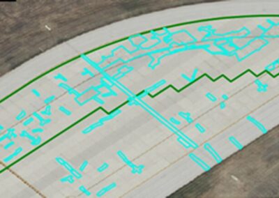
post-event analysis
Verify claims and potential loss with high resolution weather forensics.
Gauge Underwriting
Manage and Monitor Risk
We use a simple 1-10 scoring rubric to help you assess and mitigate against natural hazard and peril risks, including earthquake, hail, hurricane wind and surge, fluvial and flash flooding, sustained wind, wind gusts, ice storms, rainfall, tornados and wildfires.
When combined with our damageability and cost models, you can accurately identify at-risk structures and assets, and ensure that the proper steps are taken to mitigate any potential loss.

Beacon Forecasting
Actionable and Accurate Forecasts
Actionable, configurable intelligence to help mitigate loss from severe weather and natural hazard events. Our solution allows you to better plan resource allocation and disaster response.
Our proprietary forecast tracks were funded by the U.S. department of Homeland Security to protect critical infrastructure at home and abroad.
Dexter Post-Event
Assess, Visualize and Verify
Manage and verify natural hazard incidents at hyperlocal resolution. Dexter is a web-based weather forensics dashboard that helps you verify and manage weather-related event impacts, and understand your exposure to hazardous events within 90 mins of occurrence.
Dexter combines multi-dimensional weather data, hyperlocal resolution, and nationwide coverage to deliver the most comprehensive peril verification software available today.

What our users are saying:
Using Athenium Analytics pre- and post-storm tools has significantly improved our ability to prepare for an event and respond to our customers by allocating resources to those who need it the most first.
Our use of the Gauge tool has made a real difference in our property underwriting. Our underwriters are better armed with key location-specific indicators to inform their choices on pricing and policy conditions. And we are now able to better manage our concentration of risk and get a very good picture of our portfolio across our territory.
[Athenium] has been transformative for our Personal Lines underwriting team. The tool has multiple value-adds to our group:
- Radically improved our workflow (helps us prioritize re-underwriting actions)
- Allowed us to re-underwrite a much larger portion of our renewal book
- Leads to a more significant action than our traditional inspection program (i.e., more non-renewals, cancellations, ACV roofs)
- And costs much less than our prior process
We were impressed during [Hurricane] Florence with the ‘real time’ storm track updating. This storm was originally forecast to move through NC and up into the Chesapeake Bay area of VA. Instead, the storm took an uncommon turn to the south and instead impacted the NC/SC border area. The fact that the tool was agile in updating in real time, really helped us better understand our actual exposures.
News & Publications